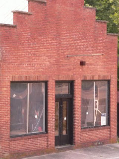
I've been invited to move my blog to al.com ("Everything Alabama"). This is very exciting! Go check out the latest post!
Earlier posts will move from this site to the new site eventually.
Tuesday, April 17, 2007
Moving over
Posted by
Anonymous
at
2:38 PM
![]()
Sunday, April 15, 2007
Barber Motorsports Park and Museum, Leeds, Alabama
 33°31'58.35"N
86°36'49.79"W
About 11 miles east of Birmingham
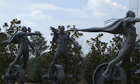
I'm afraid that I tend to view motorized vehicles in a practical light. My first criteria for the perfect car is whether it can hold a piece of plywood. My second is a minimal cringe factor when hauling sick children, injured dogs, or wet sod. This garners dramatic eye-rolling from my muscle-car-craving son. It also means that the Barber Motorsports Museum was not on my list of must-see attractions. I have edited my list. Not so much because of the enshrined vehicles as for the beauty of the museum itself. Set in a lovely park containing a 2.38 mile race track and scattered with sculptures, the museum displays 500 or so motorcycles and a variety of automobiles in a playful layout. A ramp spirals up through five floors around a glass elevator framed by racks of motorcycles. Visually, it's like a bag of M&M's in a chrome-plated dream.
The displays document the history of motorcycles and motorcycle racing. Military models brought to mind Indiana Jones movies. Board track racing must have been thrilling. I wonder if the wooden tracks creaked like the wooden roller coaster I once rode? The wall of glass at the back of the museum offers a view of the track and whimsically placed larger-than-life sculptures of bugs and birds. The bottom floor is not open to the public. It contains the restoration workshops and a tantalizing collection of unusual cars, including a solar racer built at Auburn.
The museum is open daily, including most holidays. Admission is $10 for adults, $6 for children 4-12.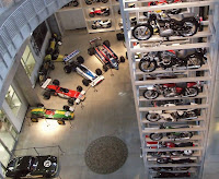
Posted by
Jeane Goforth
at
2:26 AM
![]()
Monday, April 9, 2007
Horton Mill Bridge, Blount County, Alabama
34° 0'28.64"N
86°26'53.89"W
About 39 miles northeast of Birmingham
Covered bridges are icons of touristy kitsch. I still want to visit every one. Our goal on this trip was to visit the three in Blount County. This is the only one we found. (We weren't trying very hard because it was pouring rain!)
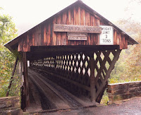
This bridge was originally built in 1894 by Thurman Horton to allow the residents of Sand Mountain to access his store and mill. As I sit fussing about a website taking 3 seconds to load, it's difficult to relate to those customers stuck on the other side of the Little Warrior River waiting for the ford to be passable to get some coffee or sugar. The completion of Mr. Horton's bridge must have been as exciting as the opening of a new mall.
The bridge was rebuilt in 1934 slightly upstream from the original and restored in 1974. It is 220 feet long and is the highest covered bridge over water in the U.S. It's right off of Highway 75, is well marked, and has a p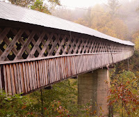 icnic area.
Alabama has 11 covered bridges which are designated in a Covered Bridge Trail. We will definitely be following the trail, although probably in chunks rather than all at once! There is also a collection of covered bridges, including this one, on Google Earth.
Saturday, April 7, 2007
Calendar Note: Visit the Artrain this weekend!

We drove to Calera to see the Artrain at the Heart of Dixie Railroad Museum. The 4-car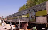 museum contains artwork by Native Americans, a couple of working artists, and a tiny gift shop. The art was beautiful and thought-provoking. The only disadvantage to a train-based museum is that it's difficult to get far enough away from a few of the larger pieces. We also enjoyed wandering among the rows of train cars in the yard of the Railroad Museum.
Monday, April 2, 2007
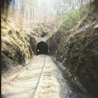
Oak Mountain Tunnel, Leeds, Alabama: Haunted by John Henry?
 33°31'2.07"N
86°32'47.41"W
About 15 miles east of Birmingham
While researching Calcis, Alabama, I came across excerpts from the journal of E. L. Voyles, a road superintendent for the Seaboard Air Line Railroad during the first half of the twentieth century. He claimed that trains passing through the Oak (Mountain) Tunnel would blow their steam whistles to honor John Henry, who, many believe, died at this tunnel after his race with the steam driver.
According to Dr. John Garst, from the University of Georgia, reliable eye witness accounts indicate that the famous contest took place on Thursday, September 20, 1887 near where the southeast portal was under construction. Other researchers believe the contest took place at the Big Bend Tunnel in West Virginia, where a statue honors the legendary railroad worker. Dr. Scott Nelson, from the College of William and Mary, has written a book, Steel Drivin' Man, that places the events at Lewis Tunnel, in Virginia on the same rail line east of the Big Bend Tunnel. (I had no idea that there were scholarly and territorial battles mildly raging about a folksong. I have always put the John Henry legend
in the same genre as stories about Paul Bunyan
and Pecos Bill
, not needing a basis in fact to enjoy the story.)
The Oak Mountain Tunnel is just south of Leeds, Alabama along Highway 25. We had to park at th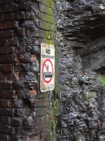 e base of a cell tower and scramble through the woods to get to the northwest portal. (Not every vehicle could maneuver the very steep drive to the tower. My Honda Element almost got stuck trying to turn around at the bottom. For once on our adventures, cell phone coverage was excellent: my boss called as I tried to find a graceful route back out of the railroad cut.)
The cut is narrow, so we noted the wide spots we could retreat to in case of train. The tunnel is wet, but well-maintained. Even though Mr. Voyles said numerous railroad employees "had strange feelings between Oak Signal and the tunnel portal" and "most Central Engineers believed that John’s ghost haunted Oak Tunnel," we did not see or feel any ghostly presence on a warm, sunny spring day. It's easy to imagine better results on a misty moonlit night. We wanted to explore the other portal for the steel rod that supposedly is left from the race, but weren't brave (stupid!) enough to venture through the tunnel. We will attempt to gain access to that side by road on our next visit.
Sunday, April 1, 2007
Clarke County Democrat Editorial: We're Not in Kansas Anymore

Jim Cox, editor and publisher of the Clarke County Democrat, has published an editorial that addresses precisely why I started this blog. Alabama is full of wonderful people and places, mostly unexplored by the average citizen. Stepping beyond our everyday paths, we can find diversion, stretch our brains, and broaden our perceptions of the state.
Friday, March 30, 2007
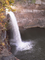
DeSoto Falls & Desoto State Park, Alabama
34°32'56.99"N
85°35'24.15"W
About 100 miles NE of Birmingham
Alabama seems obsessed with the explorer Hernando DeSoto. His name is on signs, plaques, and places. Undoubtedly, he would be pleased. He was ruthless, cruel and had a huge ego--which is why he succeeded. The journey through Alabama must have been largely unpleasant for his companions--endless travel, deprivation, illness, and a difficult boss. Perhaps a more benevolent pioneer--or better, a Native American--should have given their name to the lovely falls and park on Lookout Mountain.
When we visited DeSoto Falls last summer, the water flow was disappointingly low. However, the Huntsville Cave Rescue Unit was setting up a Tyrolean traverse above the falls as a fundraiser. We spent an hour watching the preparations, a few heart-stopping test rides, and, finally, the stream of thrill seekers. As usual, we enjoyed watching and listening to the audience of HCRU members and family sprinkled with a few tourists. In the fall, bountiful rain kept our focus on the water. Now it is difficult to im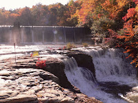 agine the attitude of Arthur Miller, who, back in the 1920's, looked at this gorgeous spot and thought of generating electricity. He is responsible for the dam above the falls. Although I'm sure the women of Fort Payne were grateful to have power for their irons every Thursday afternoon, I long to see the falls in its natural state.
DeSoto State Park has a lodge, camping, and hiking and biking trails. We like to take the Azalea Cascade Boardwalk and then wander through the maze of trails that branch out from there. (A map is available at the store along the main road.) We always walk down to Indian Falls, as well. In a typical juxtaposition for Alabama, the trail to this pretty little spot circles around the park's sewage treatment plant.
Posted by
Anonymous
at
7:11 AM
![]()
Labels: Alabama, Dekalb, natural wonder
Wednesday, March 28, 2007
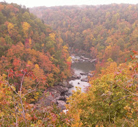
Little River Canyon, Alabama
34°21'8.18"N
85°40'27.52"W
About 86 miles NE of Birmingham
We happened on Little River Canyon by accident a decade or so ago while on a Sunday drive to Desoto State Park. The canyon's beauty took our breath away. We couldn't believe we'd never heard of it. Our visit on a misty Sunday morning last fall was a sweet end to a few days on Lookout Mountain.
The National Park Service has remedied the potholes, crumbling cement, and wrecked cars on the cliff that slightly soured our first impression. We met a friendly photographer at Little River Falls near the north end of the reserve. He showed us his portfolio, including a bob cat he'd seen on the canyon rim. In summer the falls is crowded with swimmers.
I heard a rumor that large alligator gar can be seen swimming in the pools below. I have checked at every overlook on every visit, with no success. We did see some deer, turkeys, and many other birds. We spent some time watching doves (or pigeons?) swirling off the cliffs into a few wispy cloudlets.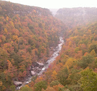
At one of the overlooks we were puzzled by crime scene tape strung among the trees. Later we read that a pickup truck with a body had been spotted on the cliff below that morning. That makes our enjoyment of the scenery seem frivolous somehow.
There are picnic tables at several spots along the main road. There is a hiking trail to the bottom of the canyon which we have never ventured on. The Little River is very popular for kayaking.
Update 04-18-2007: An article by Jennifer Bacchus indicates that Jacksonville State will build a field school in the park that would be "a place where students and professors could study and do experiments, a lab facility with offices for the park officials and room for visitors to learn about Little River Canyon and the ecology of Northeast Alabama."
Posted by
Jeane Goforth
at
12:17 AM
![]()
Labels: Alabama, Cherokee, Dekalb, Google Earth, natural wonder, Panoramio
Sunday, March 25, 2007
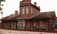
Train Depot, Stevenson, Alabama
34°52'7.00"N
85°50'22.00"W
About 107 miles NE of Birmingham
Prompted by an entry in Alabama Off the Beaten Path, we visited Stevenson on our way to Russell Cave. The depot houses a museum of local history that we spent an enjoyable hour browsing through. The attendant graciously narrated our tour through each room, bringing the culture of the area alive. She explained that the stuffed eagle was electrocuted just outside of town and that the Christmas tree of kitchen gadgets stayed up year round because it turned out to be the best way to display them. She also showed us the Christmas decorations she was sorting through, explaining how she'd stretched the museum's meager budget at after-Christmas sales. My favorite exhibit was the room hung with a long series of class photos from the high school. Each included the staff, so I watched the secretary and principal as they aged and the students documented the march of fashion.
Next to the depot is the former hotel, currently hosting city offices. Only the truly exhausted must have slept well so few inches away from the tracks.
Stevenson Depot Days are held every year in June. And the depot is decorated annually for the winter holiday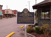 s.
s.
When we go back, we will look for Fort Harker and Little Brick.
Saturday, March 24, 2007
Calendar Note: Artrain USA April 5-10, 2007
Calera, Alabama
The Artrain USA, an art museum in a train, will be at the Heart of Dixie Railroad Museum. Presented by the Academy of Fine Arts of Shelby County, the featured exhibit is Native Views: Influences of Modern Culture. (Not open Easter Sunday.) We do plan to visit this.
Calendar Note: North Alabama Birding Festival May 4-6, 2007
Decatur, Alabama
Picked up a brochure for this activities when we visited Natural Bridge. There will be talks, classes, field trips and an expo. Most require pre-registration--except for the expo at Rhodes Ferry Park, which is open to the public and free. Much as I would love to, I can't go because of end-of-the-year concerts at work. If you go, please let me know what it is like.
Monday, March 19, 2007
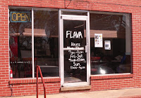
Flava Restaurant, Greensboro, Alabama
 About 72 miles SW of Birmingham
905 Tuscaloosa Street
334-624-4547
We were passing through Greensboro at 2 pm, desperate for a bite to eat. We looped past the fast food places and through downtown a couple of times before deciding to stop at this tiny diner. As we entered, an older gentleman at one of the tables directed our attention to the daily specials on a white board. The 'meat & two vegetables' ($4.99) selections, which included chitterlings and neckbone, perked our interest. Shortly after sitting at one of the three or four tables, we were brought glasses of really flavorful tea. We had the whiting & fries, one of the daily specials ($3.50), and a bacon cheeseburger ($3.29). As we waited for our order, we watched a stream of take-out customers and studied the details of the menu. Flava offers many items we would love to try: salmon biscuits and bologna biscuits for breakfast, a pork chop sandwich, not to mention the chitterlings and neckbone. The two large fillets of whiting, lightly breaded with cornmeal and fries, were tender and tasty. The bacon cheeseburger was just like homemade--fresh, juicy, wonderful. The service was friendly, attentive, and efficient. Next time we are near Greensboro, we will stop by Flava to sample more.
Posted by
Jeane Goforth
at
12:39 AM
![]()
Labels: Alabama, Hale, restaurant
Wednesday, March 14, 2007
Russell Cave National Monument, Alabama
34 deg 58' 46.39" N
85 deg 48' 34.68"W
About 5.8 miles NW of Bridgeport
Nestled in Doran's Cove in the Appalachian foothills up against the Tennessee border, Russell Cave National Monument had few visitors when we dropped by last fall. It seems to have been more popular with prehistoric Americans. The cave has evidence of 10,000 years of human occupation. A free ranger-guided tour goes over the site of an extensive excavation conducted jointly by the Smithsonian Institution and National Geographic in the 1950's. There are fine exhibits and a movie in the visitor center, but I preferred the booklet we purchased reprinting an article from the October, 1956 National Geographic Magazine.
There are picnic tables at the visitor center with a large open area that hosts a Native American Festival in May. There is also a nature walk that is a stop on the North Alabama Birding Trail.
The ranger that gave our tour through the cave shelter was from Orme, Tennessee, just up the valley. She said that when there is flooding along the stream that comes to the surface in the park and flows into the cave, the rangers are always surprised by the quantity and variety of debris from Orme that ends up in the cave. We decided to slip briefly into another state to investigate. Orme is a former railroad town with little to offer the tourist beyond a picturesque train station. We didn't mind. We were very satisfied to soak up the intense fall colors all along the valley.
Posted by
Anonymous
at
2:15 PM
![]()
Labels: Alabama, archaeology, Google Earth, Jackson, natural wonder, Roadside America
Monday, March 12, 2007
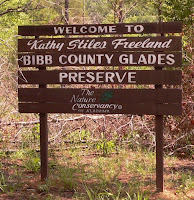
Bibb County Glades, Alabama
33° 3'33.03"N
87° 2'4.14"W
About 35 miles southwest of Birmingham
Have you ever seen a U-Haul truck with the Alabama pink root graphic? It depicts a unique biological community along the Little Cahaba River discovered in 1992 by biologist Jim Allison. These dolomite glades are home to many rare plants, eight of which grow nowhere else in the world. The Nature Conservancy's Nancy Stiles Freeland Bibb County Glades Preserve encompasses 480 acres of the Ketona glade ecosystem and the remains of the Brighthope Furnace. It is a short walk from the gate across the entrance road to the river, which is a nice spot for a picnic. (There are no facilities.)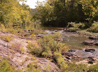
Brighthope (or Little Cahaba) Furnace was built by William Phineas Browne to provide iron for the Confederacy. It was destroyed by the Union army. Dr. James Day was kind enough to provide us with a copy of his doctoral thesis "'Diamonds in the Rough': A History of Alabama's Cahaba Coal Field," which recounts Mr. & Mrs. Browne's struggles to develop their coal and iron businesses. Rhonda Ellison's book, Bibb County, Alabama: The First Hundred Years, gives a description of the dam and furnace site (pg 101). We will try to find evidence of both on our next visit.
Posted by
Anonymous
at
12:55 AM
![]()
Labels: Alabama, Bibb, Google Earth, natural wonder, Panoramio
Friday, March 9, 2007
Birmingham Museum of Art, Alabama
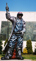
I'm always amazed at how many residents of Birmingham and Alabama (and probably anywhere) are unaware of the myriad places in their neighborhood that are worth visiting. Natives tend to stick to the familiar. Transplants moan about being in a cultural backwater. Recently we did our Showcase Recital at Boutwell Auditorium. We gave directions using the Birmingham Museum of Art as a landmark--and many didn't know the place. What a shame! The Birmingham Museum of Art is definitely a regional treasure. It has a world-class Wedgewood collection, which prompted my then 5-year-old son to comment that this museum had "way too many dishes". He was soon won back by the display of samurai weaponry.
Personally, I am fascinated by native American quillworking. Before Europeans tra
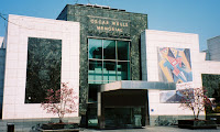 ded for beads, native American women used dyed porcupine quills to decorate clothing. BMA has some nice examples--I think better even than the Denver art museum.
We usually plan our visits around the special exhibitions. The museum is open every day except Monday and a few holidays. Admission is free, with a donation box at the entrance. Parking is free (after validation) in the museum's lot off of 21st Street.
Tuesday, March 6, 2007
Dual Destiny Monument, Double Springs, Alabama
34 deg 8' 47.23"N
87 deg 24' 8.01"W
About 55 miles NW of Birmingham
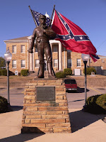
We were once again lead by a post on Google Earth to the heart of Double Springs, county seat of the 'Free State of Winston'. This monument, with the Winston County courthouse in the background, is moving testimony to the pain of civil war.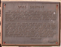
Posted by
Jeane Goforth
at
2:04 AM
![]()
Labels: Alabama, Google Earth, monument, Roadside America, Winston
Sunday, March 4, 2007
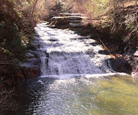
Kinlock Falls, Bankhead National Forest, Alabama
34° 18' 31" N
87° 30' 06"W
About 68 mi NW of Birmingham
Kinlock Falls is along Hubbard Creek in the Bankhead National Forest. It is in the southwest corner of Lawrence County. We chose to visit based on Indiana Joe's post on Google Earth. It was very cold when we visited, with long icicles hanging over the water. Even so, we could imagine relief from summer heat in an old fashioned swimming hole. How fun to slide down the falls!
After some research, we will go back to explore the ruins around this monument just beyond the falls. The area appears to have some interesting stories to tell!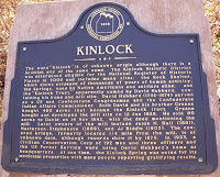
Posted by
Jeane Goforth
at
3:42 AM
![]()
Labels: Alabama, Google Earth, Lawrence, natural wonder
Tuesday, February 27, 2007
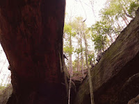
Natural Bridge, Alabama
34 deg 5' 24.47" N
87 deg 36' 54.26"W
About 60 miles northwest of Birmingham
Natural Bridge is a delightful little town with an unofficial population of 28. Natural Bridge Park surprised us with its beauty. Admission of $2.50 per person is collected in a gift shop full of classic souvenirs. Past the artesian water fountains and the rock formation resembling an Indian face is a trail to the natural bridge. The trail continues under the bridge and for perhaps half a mile along the rocks to a beautiful falls. This park would be a refreshing place for a picnic during the summer heat and must be spectacular in the fall.
Posted by
Jeane Goforth
at
2:00 AM
![]()
Labels: Alabama, Google Earth, natural wonder, Panoramio, Roadside America, Winston
Friday, February 23, 2007
Crenelated Water Tower, Marvel, Alabama
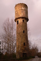
33 deg 8' 49.95"N
87 deg 0' 7.47"W
About 28 miles southwest of Birmingham
Marvel was a mining town in the Cahaba coal fields. Roden Coal Company operated there from the early 1900's until the 1950's. Although many people still live in the town, this water tower is a striking remnant of more prosperous times. The top is crenelated and a ladder angles out of one of the windows, which must require more acrobatics to climb than I'd be willing to do at that height. I've never seen a concrete water tower before and I would like to know how it was constructed. MSHA has a photo of the mine's surface plant with a note that there was an explosion on October 22, 1916 that killed 18 miners.
Next time we visit Marvel, we'll look for the mine ruins.
Posted by
Jeane Goforth
at
2:14 AM
![]()
Labels: Alabama, Bibb, Google Earth, Panoramio, Roadside America, water tower
Tuesday, February 20, 2007
Peach Water Tower, Clanton, Alabama
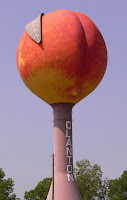 32 deg 53' 11.56"N
86 deg 37' 32.29"W
About 45 miles south of Birmingham
I almost didn't post this because the water tower is such an obvious landmark while traveling Interstate 65. But slow travelers might be interested in getting a closer look. We found the 'peach' looming over an expanse of bare dirt that was almost the same color. It made a striking contrast to the summer blue sky. According to Roadside America, it is 120 feet high, holds 500,000 gallons, and was constructed in 1992. There is a peach-themed restaurant close by, but we did not eat there. Based on signage, I suspect local peaches are also available in season.
Posted by
Jeane Goforth
at
6:52 AM
![]()
Labels: Alabama, Chilton, Google Earth, Panoramio, water tower
Saturday, February 17, 2007
Slow Travel & Long Tail

My husband just asked me what the subtitle of this blog means. Here's the answer:
Slow travel? You've heard of fast food. Have you heard of its antithesis--slow food? Here's a quote from Answers.com:
The Slow Food movement was begun by Carlo Petrini in Italy as a resistance movement to fast food.
So slow travel is like slow food. No freeways, stopping at every historic marker, talking to the guy in the gift shop.
Long tail? Here's another quote from Answers.com:
Developed by Wired Magazine editor Chris Anderson, who turned the notion into a book in 2006 entitled "The Long Tail: Why the Future of Business is Selling Less of More," the title refers to a graph showing fewer products selling in large quantities versus many more products that sell in low quantities. The low-quantity items stretch out on the x-axis of the graph, creating a very long tail that generates more revenue overall. Even though a smaller quantity of each item is sold, there is a much greater variety of these items to sell.
The long tail is all of those interesting spots on the map that only a few people want to visit and don't get featured in the travel magazines.
Posted by
Jeane Goforth
at
4:14 PM
![]()
Labels: definition
GBBC Update
We have a mockingbird haunting our deck today--but probably not the 'headless' one shown below. He's shooing away all the birds trying to visit the feeder. I saw him slam into a redwing blackbird so hard that feathers flew. He's definitely hindering our bird counting. This afternoon he's a bit distracted. He's sitting on the sill of the picture window trying to catch the tiny rainbows made by the solar rainbow maker on that window. It's so nice to have a sunny day!
Friday, February 16, 2007
Great Backyard Bird Count, North America
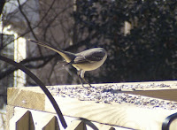
Today is the first day of the Great Backyard Bird Count.
Alabama has wonderful birds and this event is a great way to begin learning about them.
As their website says, "It's fun, it's free, it takes as little as 15 minutes--and it helps the birds."
I participate in Project Feederwatch, counting birds at my feeders two days a week November through April. I see a minimum of 20 different species of birds! My relatives in Colorado are very jealous. (When I was a stay-at-home mom and needed an ego boost to compete with the supermoms, I would say I did volunteer work for Cornell.)
The GBBC is a great family activity. My children participated to earn scout badges--and still recognize most of the birds they learned about. I like to participate because I can count anywhere, not just my designated Feederwatch area. One year, my daughter and I were in Gadsden for All-State Orchestra during GBBC. I had a good time trying to identify and count the waterfowl there.
Thursday, February 15, 2007
Green Top BBQ, Dora, Alabama
7530 Hwy 78
205 648-9838
33 deg 43' 43.11"N
87 deg 00' 49.61"W
Based on posts on Google Earth and Roadfood.com, we stopped at the Green Top BBQ last weekend. The food was delicious and inexpensive. The staff was friendly and efficient. The atmosphere evoked the best of the Heart of Dixie: Nascar on the TV over the counter; white-bearded, overalled gentlemen wearing United Mine Worker baseball caps filled a booth by the window. We'll definitely stop by again.
A good description (with a photo) is at DixieDining.com.
Posted by
Anonymous
at
9:30 AM
![]()
Labels: Alabama, Google Earth, Jefferson, restaurant
Wednesday, February 14, 2007
Storm Damage in Eoline, Alabama
32 deg 59' 46.22"N
87 deg 14' 0.02"W
6.5 miles NW of Centerville.
Eoline is a landmark on our way to the woodpecker swamp in the Talledega National Forest.
James Spann has photos of damage from last night's storm on his weather blog.
I hope everyone there is OK and that the damage is minimal in the morning light.
Monday, February 12, 2007
Sprott, Alabama
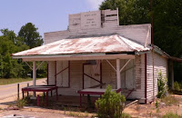
32 deg 40' 36"N
87 deg 13' 17"W
About 60 miles southwest of Birmingham
A crossroads with an abandoned store which was the subject of this Depression era photo in the Library of Congress. The store was open as recently as 1996 (photos). There is also a barn with farm equipment and another building that I would love to know the purpose of:
I wanted to see Sprott because the name always figures prominently during the coverage of tornado outbreaks. When I planned our outing to visit Sprott, I thought we would buy some lunch there. We should have brought our own!
These and more of our Sprott photos here.
Sunday, February 4, 2007
Ajars Auto Parts, Birmingham, Alabama
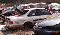 2905 Cherry Avenue
Birmingham 35214
Formerly Cherry Avenue Towing and Salvage. Mr. Estis, the owner, told me that the company change happened just last week!
This is the only junkyard we've found so far where you can poke around the cars yourself. The juxtapositions are fascinating. The personal belongings left behind are poignant.
My son is an art student who is interested in customizing cars. He loves this place. The people are friendly, informative and helpful. We're going back for the chief: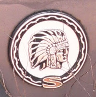
Thursday, February 1, 2007
Beaunit Rayon Factory, Childersberg, Alabama
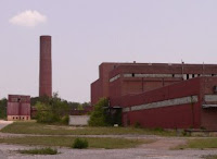
33 deg 22' 29.3''N
86 deg 19' 58.9"W
5.8 miles north of Childersburg on Hwy 235
This abandoned factory is on the edge of the Alabama Army Ammunition Plant.
It's a Superfund site. It's for sale. Search here using a minimum square footage of 600,000 to see a property description and an areal view.
There's an endangered (private) cemetery adjoining the property.
I was surprised to find that Beaunit was (is?) a subsidiary of my husband's employer, El Paso Corp.
Saturday, January 27, 2007
Calcis, Alabama
About 22 miles southeast of Birmingham.
A small community presumably named after the limestone quarried nearby. This stone was used in construction of the Logan Martin Dam. The abandoned Justice store stands at the crossroads. Next door, an old house with gingerbread decoration is being restored.
Some history here.
Photos here.
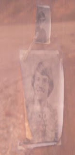
Seen through the store window:
My Goals
The purpose of this blog will be to document my exploration of the obscure yet interesting places in the world--beginning with my backyard.
I intend for this to be a reference for myself and perhaps for others.
The plan is to post at least one spot every week and to spend at least one weekend per month touring to someplace new.
Posted by
Jeane Goforth
at
6:14 AM
![]()
